Verify City Skyline Webcams in One Click
Your fastest routes to city skyline webcams are a map-based aggregator, an official aviation or transport agency feed, or a dedicated tourist landmark cam. For a quick start, open an aggregator map like GlobeWebcams and search by city or landmark name. Each source type serves a different need, and checking timestamps matters more than picking the prettiest thumbnail.
TL;DR:
- Using an aggregator map to compare multiple skyline views saves time and allows easy comparison of different vantage points within the same city.
- Verifying if a webcam feed is live involves checking timestamps against visible conditions and comparing the source’s last-updated information for accuracy.
- Tourist and landmark cams are designed for aesthetic views and timelapses, while official agency and transport cameras prioritize visibility and safety over visual appeal.
- Official weather and transport feeds are more reliable for real-time conditions, but often serve operational purposes rather than scenic viewing.
- Starting your search with platforms like GlobeWebcams ensures source-verified streams, and always confirm current status at the original provider before relying on a feed.
GlobeWebcamsFind Skyline Views By LocationBrowse source-checked public webcams by city, landmark, country or category, then compare current views through one interactive global map.Explore webcams on the map
Table of Contents
- Where to search for live skyline views
- How to verify a skyline webcam is live and reliable
- Tourist landmark cams versus agency and transport cams
- How GlobeWebcams helps you find verified skyline streams
- Where to check camera provenance and program details
- Start browsing skyline views on GlobeWebcams
- Sources
- FAQ
Where to search for live skyline views
Skyline cameras live in scattered corners of the internet, and knowing which type to check first saves time.
Aggregator maps and directories pull scattered camera sources into one interactive view, organized by country, city or category, so you are not hunting through dozens of individual agency and attraction sites. This matters most when you want to compare several vantage points of the same skyline, such as a harbor view against a rooftop view, without opening a dozen browser tabs.
Official public agency feeds serve a different purpose. The FAA runs a public Weather Camera Program and publishes airport and regional camera images at weathercams.faa.gov, built for aviation situational awareness rather than scenic browsing. Some state departments of transportation run comparable networks. Minnesota’s DOT, for instance, has discussed adding airport cameras to its 511 traveler information system, a sign that transport agencies increasingly treat camera feeds as public infrastructure rather than a niche tool.
Tourist and venue cams, by contrast, are built for the view itself. Observation decks, rooftop bars and landmark operators often run cameras designed for scenic panoramas and sunrise or sunset timelapses, with framing chosen for aesthetics rather than technical monitoring.
Live-stream platforms and social feeds round out the picture, though they come with tradeoffs: availability can be inconsistent, latency varies widely, and licensing terms are often unclear or restrictive compared with dedicated webcam providers.
A few search tactics speed things up:
- Search the city name plus “skyline cam” or “live cam” to surface both tourist and official feeds.
- Look for specific vantage points, such as harbor, tower or observation deck, to narrow results to a usable angle.
- On aggregator platforms, filter by “city” or “landmark” categories instead of scrolling an unsorted list.
How to verify a skyline webcam is live and reliable
A camera that looks live is not always current. The most common failure mode is a stale image served alongside a timestamp that suggests otherwise, a problem well documented in community reports on webcam APIs. Some webcams can return old frames while an API’s “lastUpdatedOn” field still shows a recent time, which is why a quick verification habit is worth building.
- Compare the on-image timestamp, if visible, against any separately listed “last updated” time from the aggregator or API.
- Click through to the original provider’s page whenever a link is offered, since the source page usually carries more reliable status information than a mirrored thumbnail.
- Check the technical basics: resolution, how often the frame refreshes, and whether the provider offers a timelapse mode or continuous video rather than a single static image.
- Watch for red flags such as identical frames on repeated checks, timestamps that do not match visible light or weather conditions, or no visible link back to a source.
- When in doubt, open a second nearby camera and compare conditions, since two independent feeds disagreeing is a strong signal one of them is stale.
Displayed timestamps are not always trustworthy on their own. A forensic imaging analysis notes that a camera’s reported time often reflects when software last polled or processed the image, not the moment it was actually captured, so a timestamp match is a helpful signal but not final proof.
Pro Tip: Before trusting a skyline view for a real decision, refresh the page once, then check whether the shadows or sky conditions in the frame plausibly match the local time of day.
Tourist landmark cams versus agency and transport cams
Not every skyline camera is built for the same job, and recognizing the type quickly helps you pick the right one.
- Tourist and landmark cams favor aesthetic framing, viewer-oriented overlays and timelapse options, making them the better pick for a sunrise or sunset skyline sequence.
- Agency, transport and weather cams prioritize visibility and safety over composition, and some are integrated with aviation weather reports or regional traffic systems, making them useful for a fast condition check rather than a polished view.
- A cam with wide, functional framing, a plain overlay and a link to a government or transport domain is almost always the agency type.
- A cam with curated angles, branding from a hotel or attraction, and a smooth timelapse feature is almost always the tourist type.
Aggregators typically label these categories, so filtering by “official” or “landmark” tags can save a step.
How GlobeWebcams helps you find verified skyline streams
A certain aggregator organizes public and authorized webcams on a worldwide map, with dedicated pages by country, category and place, so a skyline search in one city can lead naturally to comparable views elsewhere. Before a camera page goes live on the platform, source-rights, availability and quality checks are applied, and listings link back to the original provider rather than presenting the feed as their own.
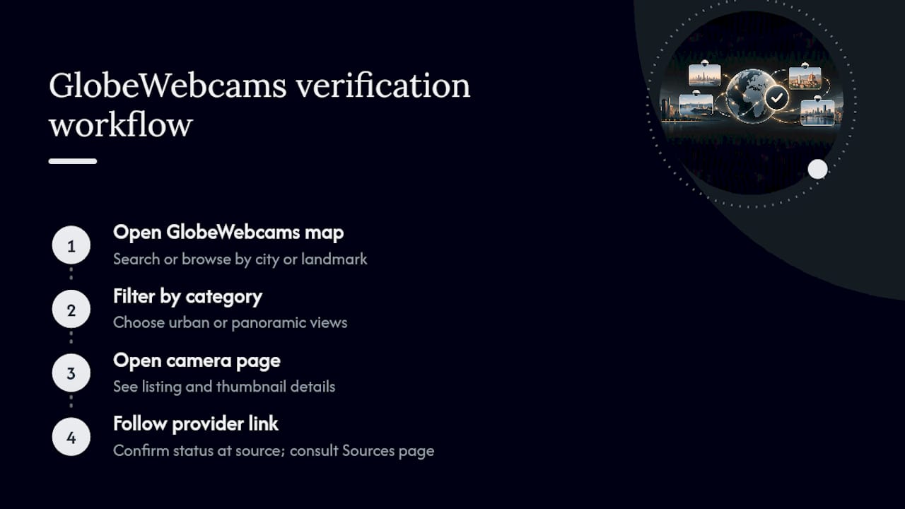
To find a skyline view, open the GlobeWebcams map and search or browse by city or landmark name, then use the category filters to narrow results to urban or panoramic views. Once you land on a camera page, open the original provider link to confirm current status directly at the source rather than relying on the thumbnail alone. Readers who want more detail on how attribution and sourcing work can check the Sources page, which explains how camera provenance is tracked and credited.
Where to check camera provenance and program details
For background on official programs, the FAA’s Weather Camera Program overview and an NTSB program dataset both document how FAA and DOT camera networks operate. Aggregators such as Argos Atlas also collect thousands of official public cameras onto one map for easier discovery.
Start browsing skyline views on GlobeWebcams
If you came here to find a specific skyline fast, certain webcam aggregator sites are designed for that job: a single map covering public and authorized cameras worldwide, sorted by country, category and place instead of scattered across individual agency and attraction sites. That structure matters most when you want to compare a harbor skyline against a rooftop view of the same city, or check a landmark cam in one country and a transport-agency feed in another without switching tools.
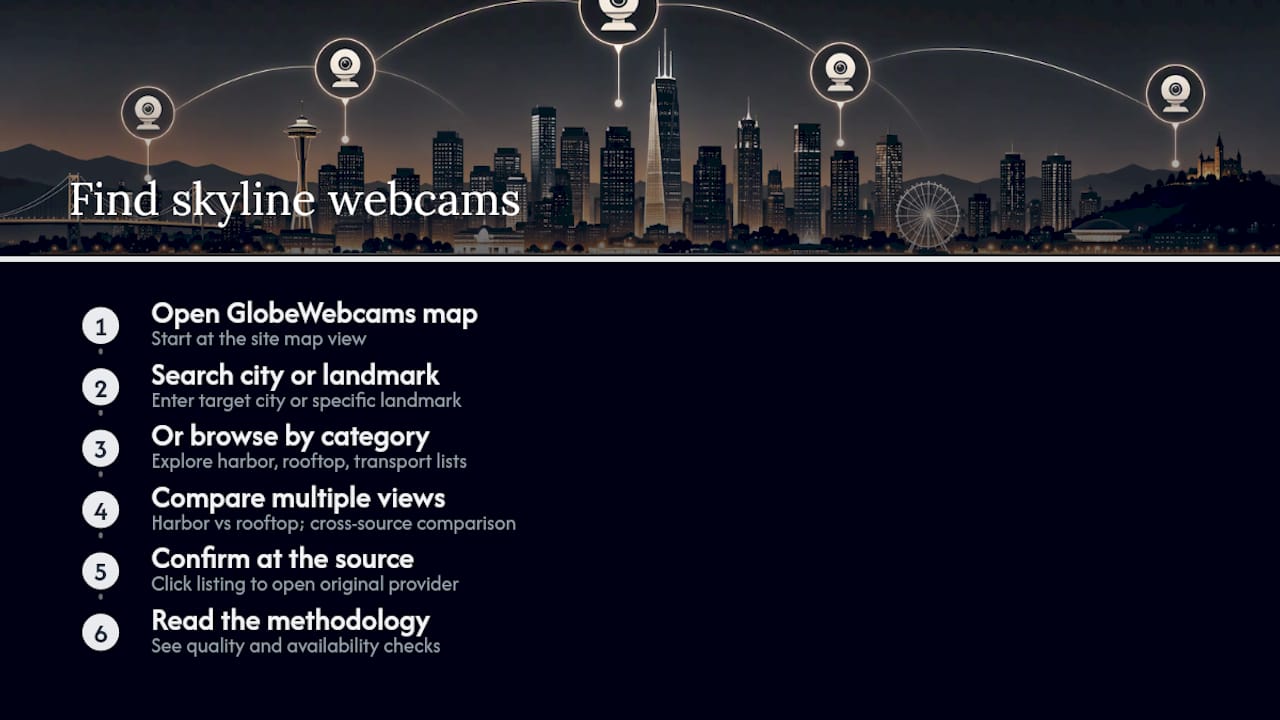
Every listing points back to its original provider, so you can confirm a feed’s status at the source in one click rather than guessing from a static thumbnail. Start at the GlobeWebcams map and search your target city or landmark, or browse by category if you are exploring rather than looking for one specific view. For readers who want the detail behind how cameras get listed, the methodology page covers the quality and availability checks applied before a feed appears on the site.
Sources
- Weather Camera Program Overview — NTSB WCAM updates (attachment)
- Possible stale webcam images despite recent lastUpdatedOn timestamps — Windy community
- Timestamps not always showing the right time — Amped Software blog
FAQ
Is there a live camera in New York right now?
Live camera availability changes constantly, and no single source guarantees uptime for every feed at every moment. Check an aggregator map or official agency page directly and confirm the timestamp before relying on the image, since a camera that was live earlier can go offline or serve a stale frame without warning.
What are skyline webcams?
Skyline webcams are cameras positioned to capture a city’s skyline, typically from a rooftop, observation deck, tower or waterfront vantage point. They range from tourist-oriented cams built for scenic timelapses to official agency cameras run by aviation or transport bodies for situational awareness rather than aesthetics.
Where can I find live webcams to watch?
Aggregator platforms such as GlobeWebcams organize public and authorized webcams by country, category and place, making them a fast starting point. Official sources like the FAA’s weather camera program and tourist or venue sites are also worth checking directly for a specific location.
Which cities have live cameras?
Cities around the world run public webcams, from tourist landmark cams to official agency feeds tied to airports and transport networks, and coverage varies by location rather than following one global standard. Searching a specific city name alongside “skyline cam” on an aggregator or agency site is the most reliable way to check what is currently available.
How do I know if a webcam feed is actually current?
Compare the on-image timestamp against any separately listed last-updated time, since these can disagree due to stale-image issues documented in community webcam reports. Clicking through to the original provider’s page and checking whether visible light or weather conditions match the local time adds a second layer of confirmation.
Recommended
- Rostock-Warnemünde DWD webcam — Warnemünde
- vt4 Kemi Etelänväylä webcam — Kemi
- vt1 Kirkkonummi Veikkola webcam — Lapinkylä
- Hamburg-Fuhlsbüttel DWD webcam — Fuhlsbüttel
Webcam availability and conditions can change without notice. GlobeWebcams does not operate most listed cameras; feeds and imagery remain under the control of their original providers. Do not rely on webcam imagery alone for weather, road, travel or safety decisions.