5 Quick Checks Boaters Use to Trust Marina Webcams
The fastest way to find marina webcams worldwide is a map-first discovery platform like GlobeWebcams, which organizes feeds by country, place, and category with direct links to the original camera operator. From there you can jump straight to a harbor or dock view in a couple of clicks. Treat every image as a visual snapshot, though, not a safety instrument. Pair it with official marine data before making any launch or navigation call.
TL;DR:
- Webcam feeds vary in update frequency and can appear frozen or outdated if not verified through timestamps or last-updated notes.
- Visual marina images only show surface conditions and traffic, not underwater hazards or offshore weather that could impact safe navigation.
- Confirm feed accuracy by checking timestamps directly on the image, source attribution, and cross-referencing official marine weather and buoy data.
- Coastal cameras are often decommissioned or offline due to weather, erosion, or maintenance, limiting their reliability for real-time conditions.
- Use webcams as a quick visual tool supplemented by official data sources before making safety-critical boat launch decisions.
GlobeWebcamsglobewebcams.comCompare Marina Views WorldwideBrowse marina webcams by location and category, then follow links to original providers for a quick visual check before your trip.Explore the interactive map
Table of Contents
- How Do You Find and View Marina Webcams?
- What Can a Marina Webcam Actually Tell You?
- How Do You Verify a Marina Webcam Feed?
- How Does GlobeWebcams Help You Discover Marina Cameras?
- Start Exploring Marina Webcams Worldwide
- Sources
- FAQ
How Do You Find and View Marina Webcams?
Locating a working marina webcam is less about luck and more about knowing where to look and what to check once you get there.
- Start with an interactive global map or a location search. Searching by country, city, or marina name narrows results fast, and a category filter for “marina” or “harbor” cuts out unrelated traffic or landscape cameras.
- Open the specific place page. A dedicated webcam page usually shows the feed alongside metadata: the operator’s name, general location, and a link back to the original source.
- Check the technical basics before assuming the feed is broken. Some marina cameras run on older codecs or require a browser to allow autoplay and pop-ups, which trips up more viewers than an actual outage does.
A few habits separate a useful five-minute check from a wasted one:
- Look for a visible timestamp on the image itself, not just the page load time.
- Note the stated refresh rate. Some marina cams update every few seconds; others push a new still frame every few minutes.
- Watch for an uptime indicator or “last updated” note near the player.
- Use a current browser (Chrome, Firefox, Safari, or Edge). Older mobile browsers sometimes block the streaming formats marina operators use.
- If the image looks frozen, reload the page before assuming the camera is down. Many feeds cache the last frame during brief connection drops.
Mobile viewing works fine for a quick look, but if you’re comparing conditions across several marinas before a trip, a desktop browser tends to load multiple tabs and station pages more reliably.
What Can a Marina Webcam Actually Tell You?
A marina webcam is genuinely good at a short list of things: general visibility, how much boat traffic is moving through the channel, whether it’s daylight or dark, cloud cover, and obvious surface disturbance like wind-driven spray or visible swell inside the frame. For a quick gut check on whether a marina “looks busy” or whether the sky is clear before a scenic outing, that’s plenty.
It’s just as important to know what the image can’t show you. A camera can’t reveal underwater hazards, a shifting sandbar, offshore sea state beyond the frame, or a squall that’s twenty minutes out and hasn’t reached the harbor yet. NWS marine weather guidance is explicit that visual monitoring like this supplements official forecasts, and never replaces them.
A few things distort what you’re seeing more often than people expect:
- Camera angle can hide a rough patch of water just outside the frame while showing a deceptively calm foreground.
- Glare off the water, especially at sunrise or sunset, can wash out wave detail entirely.
- Low light triggers grainy night-vision modes on many consumer cameras, which makes calm water look choppier than it is.
- Latency between the actual scene and what loads on your screen can run from a few seconds to a few minutes depending on the provider.
- Seasonal decommissioning happens. Some coastal camera systems get pulled or relocated when mounting sites erode, as documented in USGS’s Utqiagvik camera and buoy program, where shoreline erosion eventually forced equipment offline.
Pro Tip: A flat, glassy-looking marina surface can still sit above strong tidal current underneath. Surface calm and current strength are two different things, and only one of them shows up on camera.
How Do You Verify a Marina Webcam Feed?
Before you plan around any webcam image, run through a short verification pass. It takes under a minute and it’s the difference between “this looks current” and knowing it actually is.
- Check the timestamp on the image itself, not the time your browser loaded the page.
- Look for a page-level publish or update date. Directories don’t operate the cameras they list, so uptime and maintenance sit with the original operator, not the platform showing you the feed.
- Confirm provider attribution. A legitimate marina webcam page names who run the camera and links back to that source. GlobeWebcams applies source-rights and quality checks before publishing a page, which means the listing has been checked for a working attribution link, not that the live feed is guaranteed to be online at the moment you view it.
- Respect usage rights. Viewing a feed for personal planning is one thing; republishing the image elsewhere without the operator’s permission is another.
- Call the marina office when it actually matters. If you’re timing a departure around weather, an event, or a sudden change in conditions, a phone call or VHF check with the marina office beats any camera.
How Does GlobeWebcams Help You Discover Marina Cameras?
GlobeWebcams organizes public and authorized webcams by country, place, and category on an interactive worldwide map, so a marina in one country and a harbor on the opposite side of the globe sit inside the same simple search structure. Each listing links back to the original provider rather than rehosting the feed as its own.
Before publishing a page, GlobeWebcams runs source-rights, availability, and quality checks meant to confirm the attribution is accurate and the link actually leads somewhere useful. That’s a starting-point check, not a live uptime guarantee, since the camera itself is operated by a third party.
What this looks like in practice:
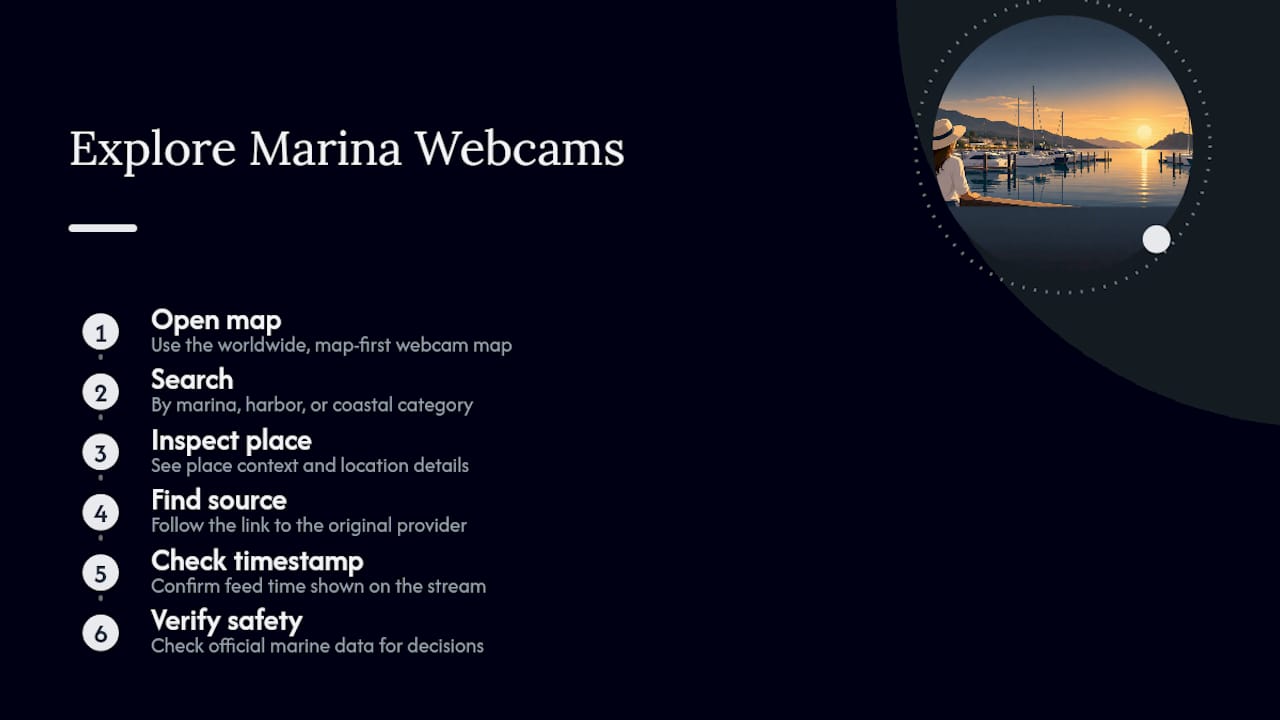
- Browse the map or search by marina, harbor, or coastal category.
- Open a place page like the Rostock-Warnemünde webcam to see how metadata and source links appear alongside the feed.
- Click through to the operator’s original page and confirm the timestamp yourself.
- Cross-check nearby PORTS, NDBC, or NWS data before treating any visual as a safety signal.
Start Exploring Marina Webcams Worldwide
Other webcam galleries exist, and some do a reasonable job aggregating coastal feeds for a quick pre-launch look. What sets GlobeWebcams apart is the combination: a genuinely global, map-first search plus dedicated place and category pages that show you exactly where a feed comes from, so you’re never guessing whether an image is rehosted or linked straight to its source.
Open the worldwide webcam map and search by marina, harbor, or coastal category to find a view near your next trip or your home dock. On arrival, you’ll see place context, a link to the original provider, and any availability notes worth knowing before you rely on the image. Confirm the timestamp on the feed itself, and for anything safety-sensitive, always check official marine data before you head out.
Sources
A webcam tells you what the harbor looks like right now. It won’t tell you what the water is actually doing beneath the surface or where the wind is headed in the next six hours. That’s where three official sources fill the gap.
- NDBC - Station CAMM2 recent data
- USGS Utqiagvik (camera and buoy systems) documentation
- NWS marine weather guidance
The pattern that actually works: visual check, then numeric confirmation, then forecast. Look at the webcam for general context, cross-reference the nearest PORTS or NDBC station for hard numbers, then check NWS warnings before committing to anything safety-critical. PORTS stations refreshing every six minutes give you a level of precision no camera frame rate can match for currents and water levels.
FAQ
Are Marina Webcams Live?
Many marina webcams update frequently, some every few seconds and others every few minutes, but “live” depends entirely on the operator’s setup. Always check the timestamp on the image itself before assuming you’re seeing current conditions.
Can I Use a Marina Webcam to Decide If It’s Safe to Launch My Boat?
No. A webcam shows visible surface conditions and traffic, but it can’t reveal underwater hazards, offshore sea state, or fast-developing weather. NWS marine guidance treats webcams as supplementary, and safety-critical decisions should rely on NOAA PORTS, NDBC, and NWS forecasts.
How Do I Find Marina Webcams for a Specific Country?
Use a map-based directory like GlobeWebcams and search or filter by country and marina category. Place pages typically show the feed alongside provider links so you can confirm the source directly.
Why Does a Marina Webcam Sometimes Go Offline or Disappear?
Coastal cameras face harsh conditions: lens fouling, power or cellular outages, seasonal removal, or repositioning for events. Some sites are decommissioned entirely when mounting locations erode, as happened with USGS’s coastal camera systems in Utqiagvik.
What’s the Difference Between a Webcam and a Weather Station Reading?
A webcam shows a visual snapshot; a station like those in the NDBC network reports measured data such as wind speed, pressure, and water temperature. Use the webcam for visual context and the station data for actual numbers.
Recommended
Webcam availability and conditions can change without notice. GlobeWebcams does not operate most listed cameras; feeds and imagery remain under the control of their original providers. Do not rely on webcam imagery alone for weather, road, travel or safety decisions.