Volcano Webcams Live: How to Watch and Read Them
The best live volcano webcams are the ones run by volcano observatories, and the easiest place to start in the United States is Kīlauea in Hawaiʻi, where the U.S. Geological Survey (USGS) publishes summit, rift zone and thermal cameras. Some of those feeds are video, some are images that refresh every few minutes, and any of them can show a quiet crater while something is happening just outside the frame. This guide shows you where to look, how to check that a view is current, and how to read what you see.
TL;DR
- Start with observatory cameras. USGS lists Kīlauea and Mauna Loa views, including thermal cameras, on its Hawaiian Volcano Observatory webcam page.
- A "live" page may be a still image that refreshes, a livestream, or a 24-hour animated GIF. Check the timestamp before you trust it.
- A quiet frame does not mean a quiet volcano. Clouds, darkness, ash or a camera pointed away from the vent can hide activity.
- Pair every camera with the observatory's latest written update. Never use a webcam alone for safety, travel or road decisions.
- Storm watching works the same way: a camera shows one place at one moment, and official forecasts and warnings come first.
Table of Contents
- What a volcano webcam actually shows
- Where to watch: Kīlauea and Mauna Loa
- Other volcano cameras worth knowing
- Live stream, refreshing image or GIF?
- How to read what you see
- Pair the picture with the official update
- Hurricane and storm webcams
- Building your own view
- Find volcano and nature cameras on GlobeWebcams
- A short checklist for your next volcano watch
- FAQ
- Sources
What a volcano webcam actually shows
A camera answers one question: what is visible from this angle right now. It cannot tell you what the volcano is doing overall. Observatories know this well, which is why the Smithsonian Global Volcanism Program describes webcams as one input among several, interpreted alongside seismic, satellite and other remote data. At Ecuador's Sangay, for example, remoteness makes ground observation hard, so web cameras and satellite data fill in part of the picture.
That has practical consequences for you as a viewer:
- Field of view. A camera on a crater rim sees that crater. Activity on a flank, a rift zone or the far side of the cone is invisible to it.
- Light. Ordinary cameras record darkness when nothing glows. Thermal cameras detect infrared radiation and may reveal hot features in darkness; thick cloud, steam, ash or an obstructed line of sight can still hide them.
- Weather. Cloud, rain, snow and ice can block a view entirely. The Smithsonian program documents cases where weather obscured webcam views at Semisopochnoi in Alaska's Aleutian Islands.
- Time. One frame is a snapshot. Repeated images over hours reveal changes in gas, ash, lava or surface temperature that a single picture can hide.
Where to watch: Kīlauea and Mauna Loa
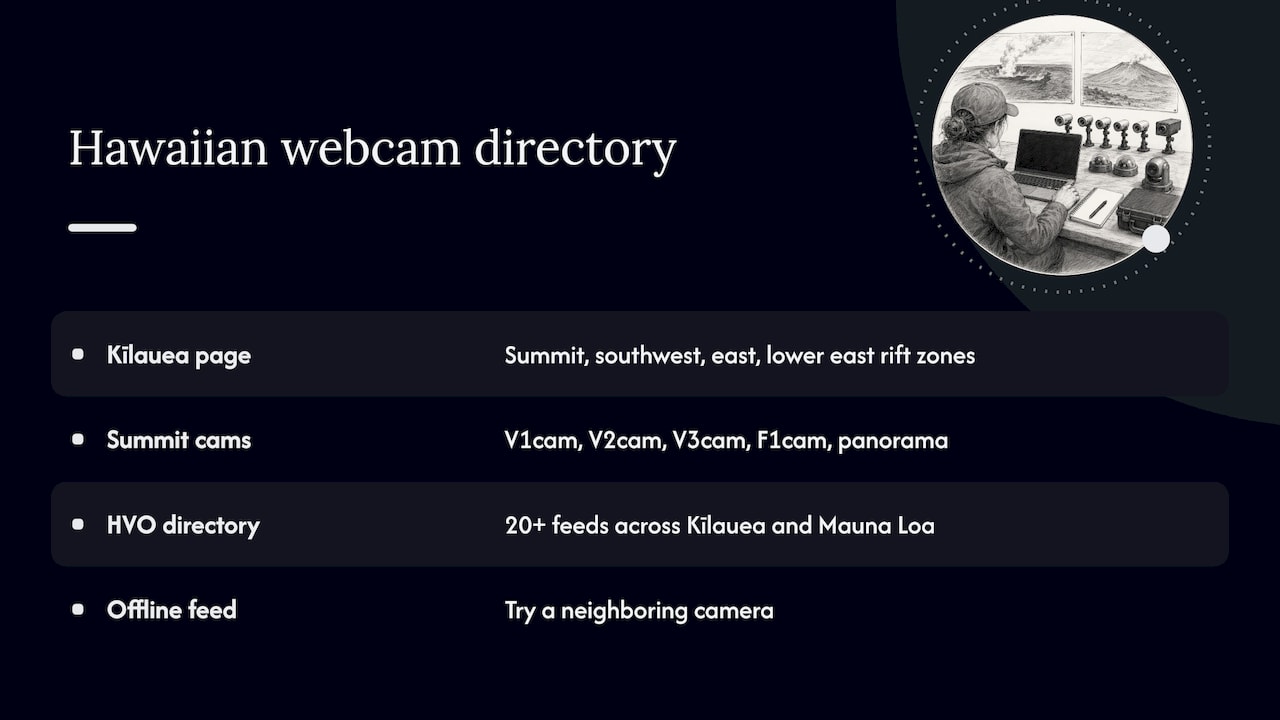
Hawaiʻi is the most reliable place to begin because the Hawaiian Volcano Observatory (HVO) publishes its own cameras and explains them. The USGS Kīlauea page groups views by summit, southwest rift zone, east rift zone and lower east rift zone, and states that the webcams show current conditions.
The summit webcam page lists several cameras, including V1cam, V2cam and V3cam, a thermal camera called F1cam, and a panorama camera. Some of the pan-tilt-zoom cameras can move, so the view may change as scientists point them at different features.
The HVO webcam directory goes further. It covers Kīlauea and Mauna Loa, from Halemaʻumaʻu crater and Kīlauea's rift zones to Mokuʻāweoweo Caldera and Mauna Loa's northeast and southwest rift zones. It offers both ordinary and thermal views, and lists more than 20 feeds. Individual cameras go offline from time to time, so if one is blank, try its neighbor.
A dated example of why context matters
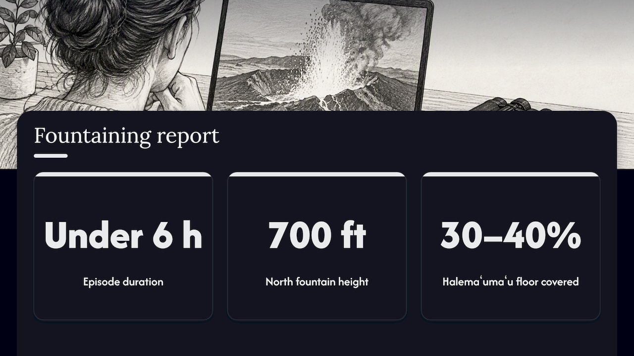
Kīlauea has been erupting in repeated episodes of fountaining. In the historical HVO messages for October 17, 2026, Episode 55 fountaining ended at 9:03 a.m. HST. The October 19 daily update summarizes a 5.7-hour episode with a maximum fountain of about 720 feet (220 m), and reports a subsequent pause. The messages page is a changing feed, so use the dated account and check the current update independently.
That is a dated report, not a promise. If you open a camera after an episode ends, you may see a glowing floor, steam, or nothing dramatic at all. If you open it during an episode, the view may be spectacular. Only the observatory's current message tells you which situation you are in.
If you are visiting in person
If you are planning a trip to the park, our Hawaiʻi Volcanoes National Park webcam page collects park views in one place. The directory also lists a northwest flank view from Hualālai volcano; Hualālai is a different volcano, so that listing should not be treated as a view of Kīlauea’s summit. Check the original provider’s location and field of view. These views help you picture the landscape and the sky. They do not replace park alerts about closures or air quality.
Other volcano cameras worth knowing
You do not need to fly to Hawaiʻi to find a volcano on screen. Other options, with the caveat that each depends on its provider:
- Yellowstone. The Yellowstone Volcano Observatory publishes webcams related to the Yellowstone volcanic system, including a camera at Biscuit Basin. These show hot springs and steaming ground rather than lava. Smithsonian's weekly reports note that in 2026 there were five small hydrothermal explosions at Black Diamond Pool, a reminder that a thermal area can change quickly even when the "volcano" itself is not erupting.
- Alaska and the Aleutians. Great Sitkin and Semisopochnoi are monitored partly by camera, but weather often blocks the view. Treat blank frames here as normal, not as a sign of calm.
- Whakaari/White Island, New Zealand. We list a Whakaari/White Island view from Whakatāne, sourced from the original provider.
- Iceland. For volcanic landscapes and weather across the country, browse our Iceland webcams.
- International lists. The BBC's editorial guide has historically pointed viewers to institutional sources for volcanoes such as Stromboli, Popocatépetl, Fuego and Sakurajima. It also warns that it is not responsible for external content, and the examples include thermal feeds, latest photographs and data pages, not just video. Check each link before you rely on it.
Live stream, refreshing image or GIF?
The word "live" covers three different things on volcano sites, and USGS itself separates them. A Kīlauea camera can appear as an individual image, a YouTube livestream or a 24-hour animated GIF. Here is how to tell them apart.
| Format | What you get | How to check it |
|---|---|---|
| Refreshing image | A still that updates every few minutes | Look for a timestamp and reload the page |
| Livestream | Continuous video, often from a pan-tilt-zoom camera | Watch for motion in clouds, steam or shadows |
| 24-hour GIF | A looping time series of the past day | Read the date range, and use it to spot change |
| Thermal camera | Heat, shown in false color | Read the legend; bright means hotter, not closer |
A few quick checks before you trust any feed:
- Find a timestamp. If the image is hours old, you are looking at history.
- Look for movement. Drifting cloud or changing light is a good sign the feed is updating.
- Compare day and night. A frame that never changes in lighting is suspect.
- Open the source. Go to the provider's own page and see whether it announces outages or maintenance.
We apply the same logic when we list cameras. Our methodology page explains the availability and quality checks, and our sources page shows where views come from. We link to the original providers and do not own or operate the cameras. Even so, a camera can fail between our check and your visit, so treat "live" as something to confirm at the source. Our guide to checking whether a wildlife feed is live uses the same approach.
How to read what you see
Visible-light views
Look for plume color and direction. White usually means steam. Gray or brown can mean ash. Either one tells you little without the observatory's description. Glow at night is the clearest signal on a standard camera, and it is also the first thing lost to cloud.
Thermal views
Thermal cameras such as Kīlauea's F1cam show temperature differences. USGS observatory practice shows why they matter: visible cameras lose detail at night or in haze, while thermal views give a different kind of evidence for heat. A hot spot on a thermal view is information about temperature, not a measure of eruption size.
Wide-angle and plume-oriented views
Wider cameras give context: where the crater sits, how the wind carries gas, whether a cloud is moving toward a road or town. They matter for aviation too, since observatories track plume height and issue color codes for aircraft.
Reading change over time
The most useful habit is to check a feed more than once. Compare the same camera in the morning and evening, or open the 24-hour GIF where one is offered. Smithsonian reports show that webcam observation is strongest as a time series, because repeated images can reveal changing gas emission, ash or lava-dome growth when a single snapshot is ambiguous.
Pair the picture with the official update
USGS activity notices do not rely on cameras alone. A May 2026 Kīlauea notice listed an alert level of WATCH and an aviation color code of ORANGE, and directed readers to observatory updates, livestreams, webcams, visitor information and hazard maps as complementary resources. That notice is a snapshot from May, and current levels may differ, so check the latest one.
A good routine looks like this:
- Read the latest HVO observatory message. It may give fountain height, plume altitude, wind direction, tephra risk and whether activity is confined to the crater.
- Open two or three cameras, ideally one visible and one thermal.
- Check the timestamps and the weather.
- Check park or road guidance if you are traveling.
If you are planning a trip near an active volcano, contact the park or local officials for closures and air-quality advice. If you have asthma or another breathing condition, ask your doctor about volcanic gas exposure before you go. A webcam does not measure what you will breathe.
Hurricane and storm webcams
Many people who search for volcano cameras also want to watch storms live, and the same rules apply. A camera on a pier, harbor or beach shows conditions at that spot, in that frame, at that time. It does not show where a storm is heading, how strong it will be when it arrives, or whether a road is passable a mile away.
For storms, the order of trust is clear:
- Forecasts and warnings first. Use the National Weather Service and National Hurricane Center for track, wind and storm surge guidance, and follow local emergency management instructions, including evacuation orders.
- Cameras second. They add context: whether waves are breaking over a seawall, whether a street is flooded, whether rain has cleared.
- Never the reverse. A calm-looking camera is not a reason to stay when officials tell you to leave, and cameras often lose power or connectivity when conditions get worst.
For coastal conditions, our guide to verifying surf cameras, buoys and forecasts shows how to check a camera against independent data. Our United States webcam directory lets you browse by state and category, so you can find coastal and weather views near a place you care about.
Building your own view
Some readers ask whether they can set up a camera of their own for a time-lapse of a nearby ridge, a storm sky or a backyard weather project. Consumer streaming gear exists for that, such as a wireless 4K streaming camera with interchangeable lenses. It will not give you a volcano view unless you happen to live within sight of one, and it will not replace an observatory feed. For watching volcanoes, public observatory cameras are the better tool.
Find volcano and nature cameras on GlobeWebcams
GlobeWebcams is a worldwide webcam discovery platform. You can open the interactive webcam map, browse by country, category or place, and follow links back to the original provider of each view. We focus on public or authorized sources, clear attribution and conservative checks. If you want more ways to find scenic and natural views, try our guides to reliable live nature webcams, national park webcams and island webcams.
A short checklist for your next volcano watch
- Choose an observatory-run camera when one exists.
- Read the latest written update before you open the picture.
- Confirm the timestamp, then reload.
- Use a thermal view at night when available; cloud and other obstructions can still limit it.
- Treat a blank or quiet frame as "unknown," not "safe."
- Compare with a second camera or a 24-hour GIF.
- Check official guidance for any real-world decision.
FAQ
Are volcano webcams really live?
Some are, and some are not. USGS publishes individual images, livestreams for certain pan-tilt-zoom cameras and 24-hour animated GIFs, and they behave differently. Look for a timestamp or visible motion, and confirm at the provider's own page.
Which volcano has the best webcams?
Kīlauea in Hawaiʻi is the most thoroughly covered in the United States, with summit, rift zone and thermal cameras from the Hawaiian Volcano Observatory. Whether it is worth watching on a given day depends on current activity, so read the latest observatory message first.
Why does the volcano look quiet on camera when the news says it is erupting?
The camera may be pointed away from the active vent, blocked by cloud or ash, or limited by darkness. Observatories combine cameras with seismic, gas, satellite and thermal data for this reason. Check the official update and a thermal view if one is available.
Can I use webcams to decide whether to travel or evacuate?
No. A webcam shows one view at one moment. For travel, closures, air quality or evacuation, follow official sources such as the observatory, park service, National Weather Service and local emergency management.
Can I watch hurricanes on live cameras?
Yes, coastal cameras can show wind, waves and rain at their location while a storm passes. They do not show a storm's track or intensity, and they can fail during severe weather, so use official forecasts and warnings for decisions.
Sources
- USGS: Kīlauea webcams
- USGS: Kīlauea summit webcams
- USGS Hawaiian Volcano Observatory: HVO webcams
- USGS HVO observatory messages
- USGS volcano notice, May 2026
- USGS: Yellowstone webcams
- Smithsonian Global Volcanism Program: Yellowstone
- Smithsonian Global Volcanism Program: Sangay report, July 2021
- Smithsonian Global Volcanism Program: Semisopochnoi report, December 2022
- BBC: Live volcano webcams
Recommended
Webcam availability and conditions can change without notice. GlobeWebcams does not operate most listed cameras; feeds and imagery remain under the control of their original providers. Do not rely on webcam imagery alone for weather, road, travel or safety decisions.