River Webcams Live: How to Find Views Worth Trusting
The best river webcams are the ones that tell you how they work. Some stream continuous video. Others post a still photo every few minutes, every hour, or only a couple of times a day. Both can be useful, but only if you know which one you are looking at. This guide shows you where river cams come from, how to read their timestamps, and how to use them for trip planning without leaning on them for safety decisions.
GlobeWebcamsglobewebcams.comFind River Views Worth ExploringBrowse river webcams by location and source, then check the original provider for timestamps and feed details.Explore river webcamsTL;DR
- A “live” label does not guarantee video. Many river cameras refresh a still image on a schedule, so check the timestamp before you trust the view.
- Government river cameras are built to read water levels, not to look pretty. Tourism boards, ports, parks and ferry operators run the more scenic ones.
- Use a river cam to judge light, fog, crowds and water color. Never use it alone to decide whether it is safe to boat, wade, drive or evacuate.
- Always go back to the original provider. A directory page should name the source, and you should confirm the feed there.
Table of Contents
- Three kinds of river webcam
- What “live” can mean
- River webcams in the United States by region
- Reading a river view for trip planning
- Where cameras stop and official warnings begin
- How we handle river cameras at GlobeWebcams
- Related views worth a look
- A short checklist before you rely on any river cam
- FAQ
- Sources
Three kinds of river webcam
Not every camera pointed at a river was installed for the same reason. The purpose explains the picture quality, the update rate and how long the feed stays online.
Hydrology and flood cameras
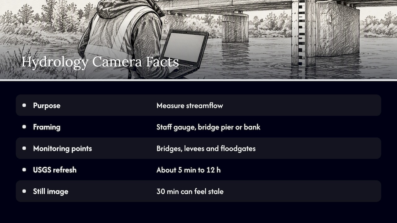
Agencies that measure streamflow install cameras next to gauges. The framing is chosen to show a staff gauge, a bridge pier or a bank, not a pleasant scene. Flood-warning guidance published through the WMO’s Typhoon Committee describes monitoring points such as bridges, levees and floodgates, which is why these views can look plain.
Update rates vary widely. The USGS Oregon Water Science Center’s camera page lists gage images, and the USGS cameras we reviewed refresh on intervals running from about five minutes to twelve hours, depending on the site’s role in flood forecasting. The USGS also maintains a page of river webcams for Illinois, Iowa and Missouri. If you are used to smooth video, a 30-minute still can feel stale. It is not broken, just built for a different job.
Tourism and community cameras
Visitor bureaus, towns, ski areas and parks mount cameras to show a place at its best. The Columbia River Gorge webcam page groups views from spots such as Hood River, Cascade Locks, Multnomah Falls and The Dalles. It points out that conditions in the Gorge can change quickly with wind, fog, rain and snow, and it also admits that some cameras update slowly or go offline. That candor is a good sign. A provider that says so is easier to trust than one that promises perfection.
Operator cameras at ports, ferries and boat ramps
Ports, ferry lines and marinas point cameras at the water because they want customers and crews to see traffic. The Cape May-Lewes Ferry, for example, runs live webcams of the Delaware Bay terminals where you can watch ferries dock and, in season, nesting ospreys. In Portugal, the Port of Lisbon launched TEJO LIVE, a free 24/7 camera on the Tagus. These feeds tend to have better framing and steadier uptime than gauge cameras, because someone’s business depends on them.
What “live” can mean
A green badge or the word “live” on a page tells you very little by itself. The same ferry operator’s guidance notes that a page may show a live badge while the technology underneath is a periodic still refresh, in some cases as rarely as twice a day. So test each camera before you rely on it.
- Find the timestamp. Many feeds burn the date and time into the image corner. Compare it with your clock, and mind the time zone.
- Look for motion. Watch for a minute. Moving boats, flags, ripples or traffic on a nearby bridge mean video. A frozen frame with a changing clock means a refreshing still.
- Reload the page. If the picture changes only after a reload, you are looking at snapshots.
- Read the metadata. The provider’s page often lists the refresh interval. USGS camera pages, for instance, state how often each site updates.
- Check sun and sky. If it is dark in the image but daylight where the river is, the feed is stuck or the camera is down.
A camera that passes these tests is probably current. Still, a view that looks current is not proof of current conditions on the ground.
River webcams in the United States by region
The US has more public river cameras than most countries, largely because federal, state and local bodies all run them. Here is how to think about the main river types and what each camera tends to show. Treat the names as starting points for your own check, not as a guarantee that any given feed is running today.
Big navigation rivers
On the Mississippi, Ohio and Detroit rivers, cameras tend to focus on barge and ship traffic, locks and bridges. The Great River Road’s Mississippi webcam listings point to views along the river corridor, including a headwaters camera and a flyway camera. These are good for seeing river stage in a general way, the color of the water and whether fog is sitting in the valley.
Gorges, canyons and mountain rivers
The Columbia River Gorge cameras are useful for wind, cloud and visibility. The same set of cameras sometimes includes highway views along I-84 and WA-14, which helps when you are planning a drive to a waterfall or a windsurfing town. Mountain towns also run cams on local rivers. Red River, New Mexico, for example, publishes webcams for its town and ski area on its own tourism pages.
Coastal rivers, estuaries and tidal reaches
Near the coast, a river camera is often really a tide camera. A tidal river can look low and muddy at one hour and full at the next. If you are planning to paddle, check a tide table from a government source as well as the picture.
Small-town river and boat-ramp cams
Some of the friendliest feeds come from small communities. Citrus County, Florida, posts live river cams at a boat ramp near Crystal River, framed so you can sit back and see what passes. Boat ramp cameras are good for a quick look at crowds and weather. If you plan to put a boat in, a separate listing of official ramps helps with the rest, such as this verified boat ramp listing for Panama City Beach and its pre-launch checklist.
Reading a river view for trip planning
A good river cam answers practical questions in under a minute. Here is what you can reasonably read from one, and what you cannot.
| You can usually judge | You cannot judge from a picture |
|---|---|
| Fog, cloud and rain at the camera | Current flow speed or hidden currents |
| Light and color at the time of day | Water quality or whether it is safe to swim |
| Boat, barge or ferry traffic | Whether a launch or crossing is open |
| Crowds at a ramp, dock or overlook | Upstream rain, releases from dams or flood risk |
| Whether snow or ice is on the banks | Road conditions beyond the frame |
Tourism experts and operators often describe these feeds as virtual windows: you see ship traffic, docking, and wildlife along the waterway, and that helps bridge the gap between planning a trip and being there. That is a fair use. A camera is a window onto one spot at one moment.
Best times to look
- Dawn and dusk: the light is best, and fog is most common over water.
- Weekend mornings: ramps and waterfronts show crowd levels before you drive.
- After heavy rain: check the color and the height of the water against how the bank looked on earlier visits. Then check official flood information.
- Seasonal events: bird migrations, salmon runs and ice-out make some cameras worth a visit. Look at the provider’s page for season notes.
Where cameras stop and official warnings begin
A webcam shows you a frame. A flood warning is built from gauges, rainfall data and forecasts. Public webcam directories, including ours, are information aggregators. They are not primary sources for disaster warnings or emergency management. Guidance associated with the WMO and national weather services says people should not rely on webcam imagery alone for safety, travel or evacuation decisions, and that local emergency and tourism authorities are the right sources for real-time alerts. One tourism report on a new Iguazú National Park camera shows how parks present cameras: as a way to enjoy a view from afar, not as a safety tool.
In practice:
- If you plan to boat, kayak or fish, check the official river forecast and any local advisories before you go. The picture only adds context.
- If you plan to drive to a river overlook, use your state’s road-condition service, not a camera frame from a nearby bridge.
- If you are in or near a flood-prone area, follow your county emergency management and the National Weather Service. Do not wait for a camera to show water on the road.
How we handle river cameras at GlobeWebcams
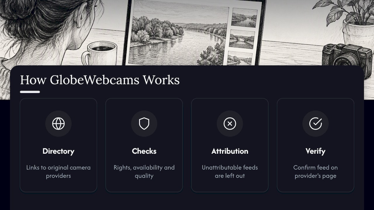
We do not own or operate any of the cameras you see through us. GlobeWebcams is a directory: we link to the original providers, name the source, and apply source-rights, availability and quality checks before we publish a webcam page. We would rather leave a feed out than list one we cannot attribute. Our sources page explains the providers behind the pages.
If you want to explore by place, start with the worldwide webcam map and zoom to a river or region. Then open the United States webcam pages to browse by place and category, or try the Canada, Australia and Norway pages if you are planning farther afield. For lake and island scenery, the Isle Royale webcam page is one example of a park-based view of Lake Superior waters. Whatever you open, confirm the feed on the provider’s own page.
Related views worth a look
Rivers are one piece of water-watching. If you are heading to the coast or a harbor, these guides use the same verification approach:
- Marina webcams: quick checks boaters use before trusting a dock view.
- Live surf webcams: how to pair a camera with buoy data.
- Cruise port webcams: official harbor views and what to verify.
- Underwater webcams: sources and schedules.
- Sea otter cams: how to confirm that a stream is current.
- Boston Harbor Islands webcams: a national recreation area view of the harbor.
A short checklist before you rely on any river cam
- Who runs it? A port, a park, an agency and a town each have different reasons to keep it running.
- How often does it update? Look for a stated interval, not just a badge.
- Is the timestamp current, in your time zone?
- Is there motion, or is it a still?
- What does the camera not show? Upstream water, currents, ramps and roads are all outside the frame.
- What do the official forecast and local advisories say?
Two minutes with this list will tell you whether a feed is a handy window or a stale picture.
FAQ
Are river webcams really live?
Some are, and some are not. Operator and tourism cameras often stream video, while many government hydrology cameras refresh a still image every few minutes to every few hours. Check the timestamp and look for motion to see which kind you have.
Why do some river cameras look so plain?
Many were installed to monitor water levels for flood forecasting, so they are aimed at gauges, bridge piers or banks. Scenic framing was never the goal. For prettier views, look for cameras run by tourism boards, parks, ports or ferry operators.
Can I use a river webcam to decide if it is safe to go out on the water?
No, not on its own. A camera shows one spot at one moment and cannot show currents, upstream rain or dam releases. Check the official river forecast, the National Weather Service and local authorities before you launch.
How do I find a good river webcam near me?
Start from a map and zoom to the river you care about, then open the provider’s own page to confirm how the camera works. Our webcam map lets you browse by location and category, and each page names its source.
Sources
- USGS Oregon Water Science Center: Real Time Cameras
- USGS: River WebCams for the Central Midwest Water Science Center
- WMO/Typhoon Committee: Community-Based Flood Forecasting and Warning System guidelines
- Explore the Columbia River Gorge: Webcams
- Cape May-Lewes Ferry: Live Webcams
- Porto de Lisboa: TEJO LIVE
- Experience Mississippi River: Webcams
- Citrus County: Live River Cams
- Turismo Misiones: Cataratas en vivo
Recommended
- Find Reliable Live Nature Webcams Worldwide: 5…
- Sea Otter Cams: How to Verify a Current Stream
- Mountain Webcams for Trips: Find Feeds, Check…
- Live Underwater Webcams: Sources, Schedules and…
Webcam availability and conditions can change without notice. GlobeWebcams does not operate most listed cameras; feeds and imagery remain under the control of their original providers. Do not rely on webcam imagery alone for weather, road, travel or safety decisions.